
1.Rainbow Mountain Hike
- Where: Ausangate region, Cusco, Peru
- Starting Point: Cusco or nearby towns such as Cusipata or Pitumarca
- End Point: Rainbow Mountain (Vinicunca)
- Time Needed: 4-5 hours.
- Distance and Type: 6 kilometers circuit
- Difficulty: Moderate-Difficult
- When to Hike: Dry season (May-September) to avoid the rainy season and slippery conditions.
- Where to Stay: Visitors can stay in Cusco or nearby towns such as Cusipata or Pitumarca and take a day trip to the Rainbow Mountain.
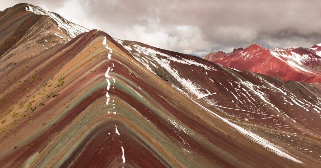
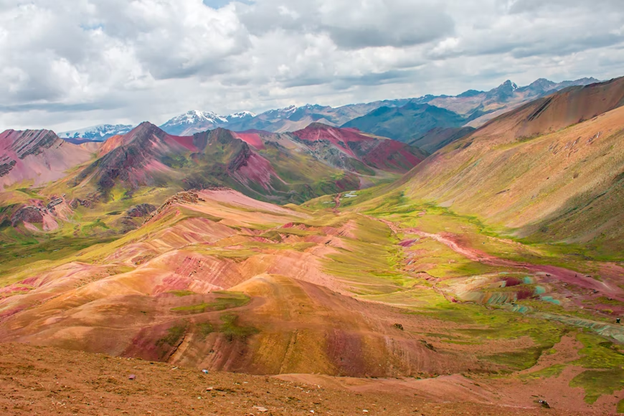
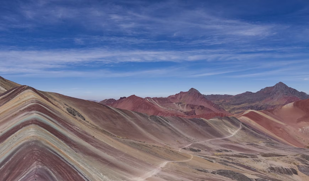
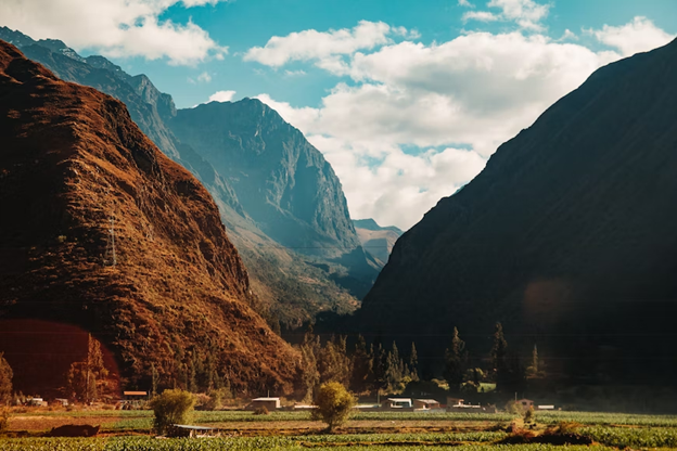
The Rainbow Mountain Hike is a popular trail in the Ausangate region of Cusco, known for its strikingly colorful landscape. The hike starts with a steep climb up a valley, gradually gaining elevation as you approach the Rainbow Mountain. The trail can be challenging due to the high altitude and steep sections, but the views at the top are worth it. Visitors can see the Rainbow Mountain’s unique striped layers of red, orange, yellow, green, and blue, as well as panoramic views of the surrounding mountains and valleys. It’s important to take the time to acclimate to the altitude before attempting this hike, as the Rainbow Mountain is over 5,000 meters (16,400 feet) above sea level. Visitors can also hire a horse or mule to help with the ascent if needed.
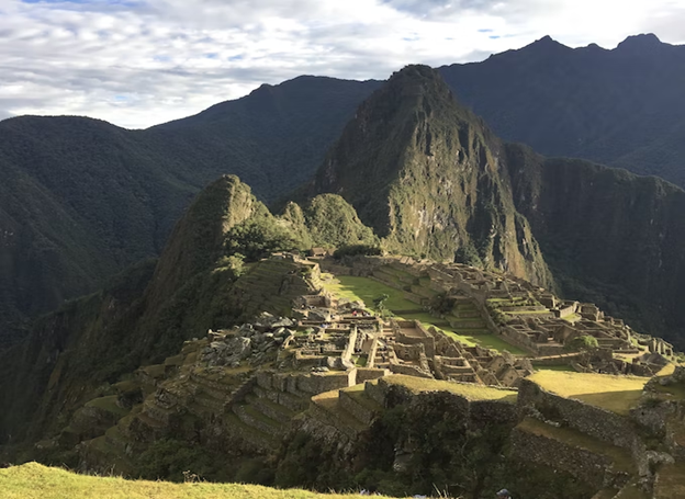
2. Huayna Picchu Hike
- Where: Machu Picchu, Cusco, Peru
- Starting Point: Machu Picchu archaeological site
- End Point: Huayna Picchu summit
- Time Needed: 2-3 hours.
- Distance and Type: 3 kilometers circuit
- Difficulty: Moderate-Difficult
- When to Hike: Dry season (May-September) to avoid the rainy season and slippery conditions.
- Where to Stay: Visitors can stay in nearby towns such as Aguas Calientes and take a day trip to Machu Picchu.
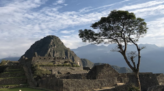
The Huayna Picchu Hike is a popular trail within the Machu Picchu archaeological site, known for its stunning views of the surrounding mountains and valleys. The trail starts with a steep climb up a narrow path with stairs and switchbacks, gradually gaining elevation as you approach the summit. The trail can be challenging due to the steep and narrow sections, but the views at the top are worth it. Visitors can see panoramic views of Machu Picchu and the surrounding mountains and valleys. It’s important to take the time to acclimate to the altitude before attempting this hike, as Huayna Picchu is over 2,700 meters (8,900 feet) above sea level. Visitors must also obtain a separate entrance ticket to access the Huayna Picchu trail.
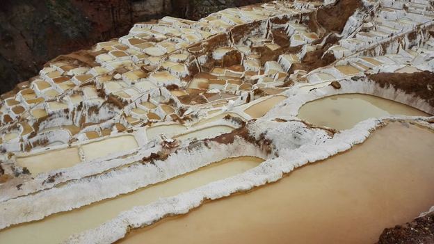
3. Moray and Maras Salt Mines Hike
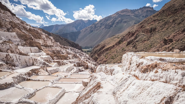
- Where: Sacred Valley, Cusco, Peru
- Starting Point: Moray archaeological site
- End Point: Maras Salt Mines
- Time Needed: 3-4 hours
- Distance and Type: 7 kilometers circuit
- Difficulty: Easy-Moderate
- When to Hike: Dry season (May-September) to avoid the rainy season and slippery conditions.
- Where to Stay: Visitors can stay in nearby towns such as Urubamba or Ollantaytambo and take a day trip to the Sacred Valley.
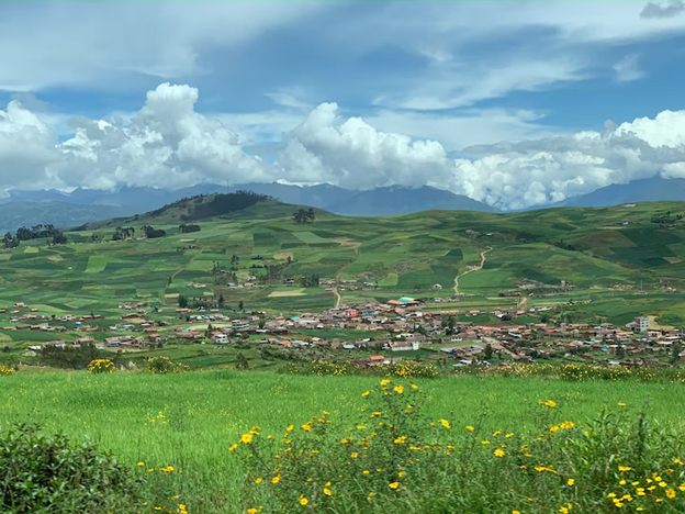
The Moray and Maras Salt Mines Hike is a scenic trail through the Sacred Valley, known for its unique agricultural terraces and salt mines. The trail starts at the Moray archaeological site, where visitors can see impressive circular terraces used for agricultural experiments by the Incas. The trail then descends through farmland and countryside to the Maras Salt Mines, a series of terraced pools used for salt mining since Inca times. Visitors can see workers harvesting salt from the pools and learn about the traditional salt mining methods still used today. The trail can be uneven and steep in some sections, but it’s generally easy to moderate and suitable for most fitness levels. The views of the Sacred Valley and surrounding mountains are also stunning.
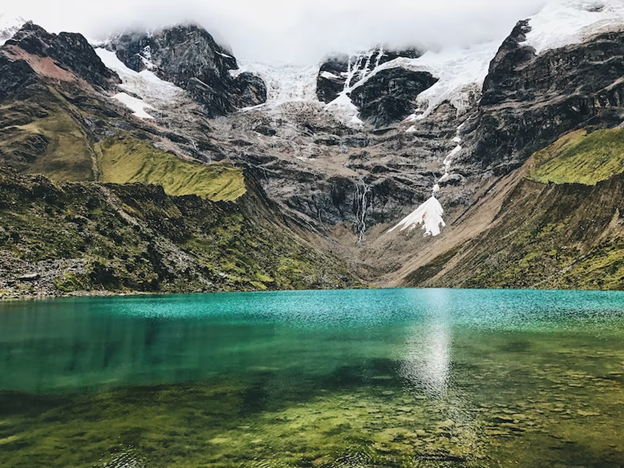
4. Laguna Humantay Hike

- Where: Cusco, Peru
- Starting Point: Soraypampa
- End Point: Laguna Humantay
- Time Needed: 6-7 hours
- Distance and Type: 7 kilometers circuit
- Difficulty: Moderate-Difficult
- When to Hike: Dry season (May-September) to avoid the rainy season and slippery conditions
- Where to Stay: Visitors can stay in Cusco or nearby towns such as Mollepata or Soraypampa for easy access to the hike.
The Laguna Humantay Hike is a challenging but rewarding trail in the Andes Mountains, known for its stunning views of the turquoise lake and surrounding peaks. The trail starts at Soraypampa and follows a steep and rocky ascent for about 3.5 km (2.2 miles) to the Laguna Humantay. The trail can be challenging due to the steep ascent and high altitude (the lake is located at over 4,200 meters or 13,800 feet above sea level), but the views at the top are worth it. Visitors can see panoramic views of the lake and surrounding mountains, including the snow-capped peak of Humantay Mountain. It’s important to take the time to acclimate to the altitude before attempting this hike, and to bring warm clothing as temperatures can drop significantly at the summit.
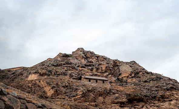
5. Pumamarca Ruins Hike
- Where: Ollantaytambo, Peru
- Starting Point: Ollantaytambo town
- End Point: Pumamarca Ruins
- Time Needed: 2-3 hours.
- Distance and Type: 4 kilometers circuit
- Difficulty: Easy-Moderate
- When to Hike: Dry season (April-November) to avoid the rainy season and slippery conditions
- Where to Stay: Visitors can stay in Ollantaytambo or nearby towns such as Urubamba for easy access to the hike.
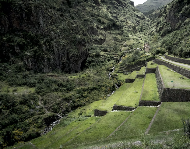
The Pumamarca Ruins Hike is a short and relatively easy hike that takes visitors to the Pumamarca archaeological site, a well-preserved Inca ruin located on a hillside overlooking the town of Ollantaytambo. The trail follows a gentle incline through fields of corn and potatoes, offering beautiful views of the surrounding mountains and valley. At the top of the hill, visitors will find the Pumamarca ruins, which are believed to have served as a military stronghold and religious center during the Inca era. The site features a series of terraces, ceremonial platforms, and stone structures that offer insight into the Inca culture and architecture. Overall, the Pumamarca Ruins Hike is a great option for those looking for a short and easy hike with beautiful views and historical significance.
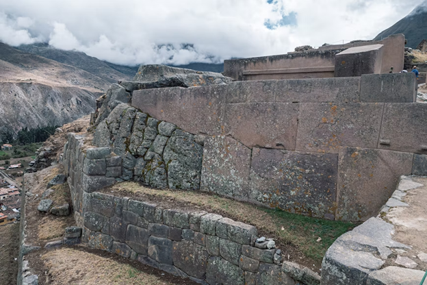
6. Ollantaytambo Ruins Hike
- Where: Ollantaytambo, Peru
- Starting Point: Ollantaytambo town
- End Point: Ollantaytambo ruins
- Time Needed: 2-3 hours.
- Distance and Type: 3 kilometers circuit
- Difficulty: Easy-Moderate
- When to Hike: Dry season (April-November) to avoid the rainy season and slippery conditions.
- Where to Stay: Visitors can stay in Ollantaytambo or nearby towns such as Urubamba for easy access to the hike.
The Ollantaytambo Ruins Hike is a short and relatively easy hike that takes visitors to the Ollantaytambo archaeological site, a well-preserved Inca ruin located on a hillside overlooking the town of Ollantaytambo. The trail follows a gentle incline through fields of corn and potatoes, offering beautiful views of the surrounding mountains and valley. At the top of the hill, visitors will find the Ollantaytambo ruins, which feature a series of terraces, ceremonial platforms, and stone structures that offer insight into the Inca culture and architecture. The site is also famous for its massive stone blocks, some of which weigh up to 50 tons that were quarried and transported from a nearby mountainside. Overall, the Ollantaytambo Ruins Hike is a great option for those looking for a short and easy hike with beautiful views and historical significance.
7. Inti Punku (Sun Gate) Hike
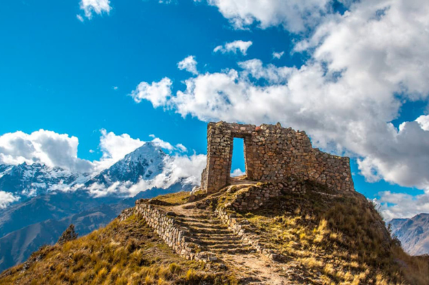
- Where: Machu Picchu, Peru
- Starting Point: Machu Picchu archaeological site
- End Point: Inti Punku (Sun Gate)
- Time Needed: Approximately 2-3 hours.
- Distance: 4 kilometers circuit
- Difficulty: Moderate-Difficult
- When to Hike: Dry season (April-November) to avoid the rainy season and slippery conditions.
- Where to Stay: Visitors can stay in nearby towns such as Aguas Calientes or Cusco for easy access to Machu Picchu.
The Inti Punku (Sun Gate) Hike is a challenging but rewarding trail that takes visitors from the Machu Picchu archaeological site to the Inti Punku. The trail starts with a steep uphill climb on stone steps, which can be challenging due to the high altitude and steep incline. However, the trail offers stunning views of the surrounding mountains and valley, making it a popular choice for photographers and nature lovers. At the top of the hill, visitors will find the Inti Punku ruin, which was once a ceremonial gateway and likely served as an entrance to Machu Picchu for important visitors. From the Inti Punku, visitors can also enjoy breathtaking views of Machu Picchu and the surrounding landscape. Overall, the Inti Punku (Sun Gate) Hike is a great option for experienced hikers looking for a challenging but rewarding trail with historical significance and beautiful views.
8. Chinchero to Urquillos Hike
- Where: Sacred Valley, Peru
- Starting Point: Chinchero town
- End Point: Urquillos town
- Time Needed: Approximately 2 hours.
- Distance and Type: 5 kilometers point-to-point
- Difficulty: Easy-Moderate
- When to Hike: Dry season (April-November) to avoid the rainy season and slippery conditions.
- Where to Stay: Visitors can stay in nearby towns such as Cusco or Urubamba for easy access to the trail.
The Chinchero to Urquillos Hike is a beautiful trail that takes visitors through the Andean countryside, passing by traditional villages, agricultural fields, and stunning views of the surrounding mountains. The trail starts in Chinchero, a small town known for its colonial church and Inca ruins and follows a well-marked dirt road towards the town of Urquillos. Along the way, visitors can enjoy the beautiful scenery and interact with locals, who are often seen herding llamas or farming their fields. The trail is relatively easy, with some moderate inclines and declines, and can be completed in around 2 hours. At the end of the trail, visitors will arrive in Urquillos, a small town with a beautiful colonial church and several local restaurants where they can enjoy a traditional meal. Overall, the Chinchero to Urquillos Hike is a great option for beginners and families looking for an easy but scenic trail with cultural significance and beautiful views of the Andean countryside.
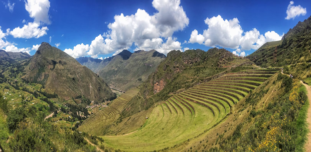
9. Pisac Ruins Hike
- Where: Pisac, Peru
- Starting point: Pisac town
- End point: Pisac ruins
- Time needed: 1-2 hours.
- Distance and Type: 2 kilometers circuit
- Difficulty: Easy-Moderate
- When to hike: Year-round, but best from April to October during the dry season
- Where to stay: Pisac town or nearby towns such as Urubamba or Cusco.
The Pisac ruins hike is a short but rewarding hike that offers stunning views of the Sacred Valley of the Incas. The hike starts from the town of Pisac and follows a steep trail that leads to the ruins, which were once a fortified citadel and agricultural center. Along the way, hikers can see Inca terraces, temples, and burial sites. The ruins themselves offer breathtaking panoramic views of the valley and surrounding mountains.
Crossfit Gym: Crossfit Cusco and here is the link to their Instagram: https://www.instagram.com/crossfitcusco
10. Tipon Ruins Hike
- Where: Tipon Ruins, Cusco, Peru
- Starting Point: Tipon Ruins main entrance
- End Point: Tipon Ruins main entrance
- Time Needed: 2 hours.
- Distance and Type: 2 kilometers circuit
- Difficulty: Easy
- When to Hike: Best time to visit is during the dry season from May to October
- Where to Stay: There are several accommodation options in Cusco city or surrounding towns.
The Tipon Ruins Hike is a short and easy loop trail that explores the Inca ruins of Tipon. The trail takes you through the terraced hillsides and past aqueducts and waterfalls that were part of the Inca’s impressive hydraulic engineering system. Along the way, you can see the remains of temples, houses, and fountains that date back to the 15th century. The trail is well-maintained and offers stunning views of the surrounding Andean Mountains. It’s a great hike for those short on time or looking for a more leisurely adventure.
Crossfit Gym: Crossfit Cusco and here is the link to their Instagram: https://www.instagram.com/crossfitcusco