
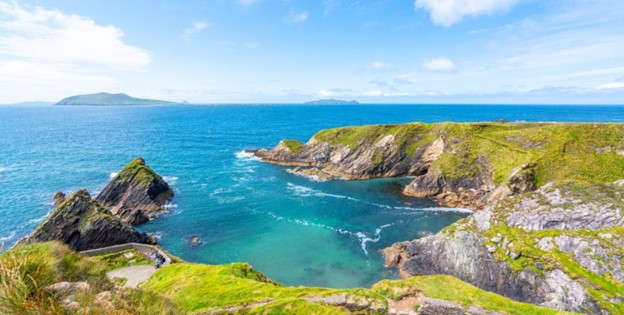
1. Bray Head
- Where: County Wicklow, Ireland
- Trail Head: Town of Bray, South of Dublin.
- Time Needed: 2-3 hours.
- Distance and Type: 6.4 kilometers circuit
- Difficulty: Moderate
- When to Hike: The best time to hike the Bray Head Loop is from April to October, when the weather is mild, and the days are longer.
- Where to Stay: There are several accommodation options in Bray, including hotels, guesthouses, and bed and breakfasts. Some popular options include the Esplanade Hotel, the Martello Hotel, and the Bray Head Inn.
The Bray Head Loop is a popular and scenic hike that takes you along the coast of County Wicklow, with stunning views of the Irish Sea and the surrounding countryside. The trail starts in Bray and takes you up the hillside to the top of Bray Head, where you’ll get panoramic views of the coastline and the town below. From there, the trail winds its way back down to the town, passing through fields and woodland areas. Along the way, you’ll see a variety of flora and fauna, as well as historic sites like the ruins of an old church and a Martello tower. Overall, the Bray Head Loop is a great hike for those looking for a short but rewarding adventure in the beautiful Irish countryside.
2. Glenmacnass Waterfall Walk
- Where: County Wicklow, Ireland.
- Trail Head: Car park at Glenmacnass Waterfall
- Time Needed: 2-3 hours.
- Distance and Type: 7.2 kilometers circuit
- Difficulty: Moderate
- When to Hike: The best time to hike the Glenmacnass Waterfall Walk is from May to October, when the weather is mild and the days are longer.
- Where to Stay: There are several accommodation options in the nearby town of Roundwood, including hotels, guesthouses, and bed and breakfasts. Some popular options include the Roundwood House Hotel, the Roundwood Inn, and the Old Rectory Country House.
The Glenmacnass Waterfall Walk is a scenic hike that takes you through the beautiful countryside of County Wicklow. The trail starts at the car park at Glenmacnass Waterfall and takes you through lush forests and past babbling brooks before reaching the stunning waterfall itself. The waterfall is a popular spot for picnics and relaxation and is a great place to take a break and enjoy the scenery. The hike continues up the glen, where you’ll see a variety of wildlife and flora, before reaching a stunning vista point with sweeping views of the surrounding countryside. Overall, the Glenmacnass Waterfall Walk is a great hike for those looking for a short but rewarding adventure in the beautiful Irish countryside.
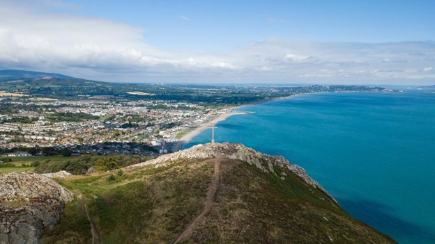
3. Howth Cliff Path
- Where: Howth, County Dublin, Ireland.
- Starting point: Howth village
- End point: Howth Summit
- Time needed: 2-3 hours.
- Distance and Type: 6 kilometers circuit
- Difficulty: Easy-Moderate
- When to hike: Best in spring or summer.
- Where to stay: You can stay in Dublin city and take a short train ride to Howth for the hike.
The Howth Cliff Path Loop is a popular and scenic hiking trail in Howth, a coastal village located in County Dublin. The hike takes you along the rugged coastline, offering stunning views of the Irish Sea and the surrounding landscapes.
The trail starts in the village of Howth, where you can easily find the starting point at the east pier. From there, the trail leads you up the hill to the cliff path. The path is well-maintained and clearly marked, making it easy to follow. Along the way, you will pass by several lookout points and scenic vistas, including the Baily Lighthouse, the Martello Tower, and the cliffs of Howth Head.
The hike continues along the cliff path until you reach the summit of Howth Head, where you will be rewarded with panoramic views of Dublin Bay and the Wicklow Mountains. From there, you can take a short detour to visit the ruins of the 15th-century Howth Castle before returning to the village via a different path.
Overall, the Howth Cliff Path Loop is a must-do hike for anyone visiting Dublin, offering a perfect combination of scenic views, history, and outdoor adventure.
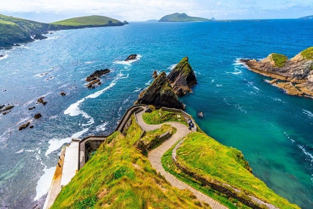
4. Slea Head Walk
- Where: Dingle Peninsula, County Kerry, Ireland
- Starting point: Dunquin village
- End point: Dunmore Head
- Time needed: 2-3 hours.
- Distance and Type: 8 kilometers circuit
- Difficulty: Easy-Moderate.
- When to hike: Best in spring or summer.
- Where to stay: You can stay in Dingle town or in the surrounding area.
The Slea Head Walk is a picturesque and enjoyable hike that takes you along the coast of the Dingle Peninsula, offering stunning views of the Atlantic Ocean and the rugged landscapes of western Ireland.
The trail starts in the small village of Dunquin and takes you along a well-marked path that leads you past the famous Dunquin Harbour and the Great Blasket Island, which was inhabited until 1953. Along the way, you will see old stone walls, small farms, and traditional Irish cottages that are characteristic of this part of the country.
As you continue along the trail, you will reach the tip of the peninsula, where you can see the stunning views of the surrounding area, including the Skellig Islands and the rugged coastline. The trail then turns inland and follows a path through the rolling hills and green fields of the Dingle Peninsula before returning to Dunquin.
Overall, the Slea Head Walk is a great way to experience the natural beauty and rich culture of the Dingle Peninsula, making it one of the best short hikes in Ireland. The trail is well-marked and not too strenuous, making it suitable for hikers of all levels of experience.
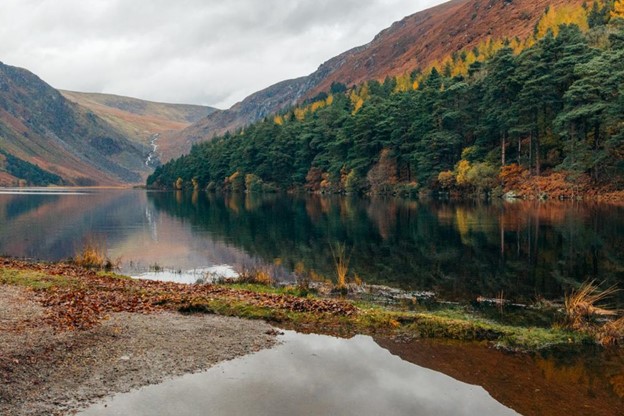
5. Poulanass Waterfall Walk
- Where: Wicklow Mountains National Park, Ireland
- Trail Head: Glendalough Monastic Site car park
- Time needed: 2-3 hours.
- Distance and Type: 6 kilometers circuit
- Difficulty: Moderate
- When to hike: The best time to hike the Poulanass Waterfall Walk is from May to September.
- Where to stay: There are several options for accommodation near the Wicklow Mountains National Park, including hotels, bed and breakfasts, and guesthouses.
The Poulanass Waterfall Walk is a beautiful hike that takes you through the stunning landscape of the Wicklow Mountains National Park. The trail follows a river and leads to the Poulanass Waterfall, which is a highlight of the hike. The trail is well-maintained, and there are several benches along the way where you can take a break and enjoy the views. The hike also offers beautiful views of the surrounding mountains and valleys. This hike is perfect for those who want to experience the natural beauty of Ireland without too much exertion.
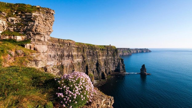
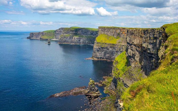
6. Cliffs of Moher Coastal Walk
- Where: County Clare, West coast of Ireland
- Starting Point: Cliffs of Moher Visitor Centre
- End point: Hags Head
- Time needed: 2-3 hours.
- Distance and Type: 8 kilometers point to point
- Difficulty: Moderate
- When to hike: The best time to hike the Cliffs of Moher Coastal Walk is from April to September when the weather is milder, and the days are longer.
- Where to stay: There are several accommodations nearby the Cliffs of Moher Visitor Centre including bed and breakfasts, hotels, and guesthouses.
The Cliffs of Moher Coastal Walk offers breathtaking views of the Atlantic Ocean and the Cliffs of Moher. The hike starts at the Visitor Centre and follows a marked path along the cliff edge, passing by several lookout points and the O’Brien’s Tower. The trail can be uneven and narrow in some areas, so it is important to take caution. The walk ends at Hags Head, where you can take in views of the sea stack and Aran Islands in the distance.
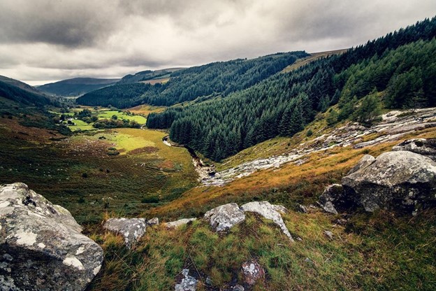
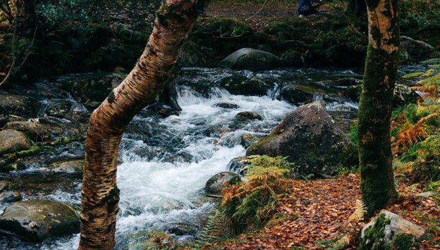
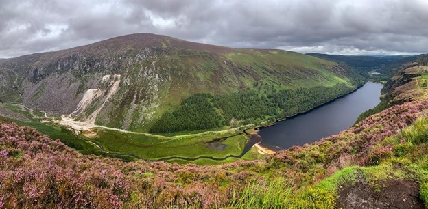
7. Glendalough Spinc Trail
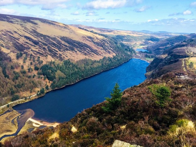
- Where: Glendalough Valley, County Wicklow, Ireland
- Trail Head: Glendalough Upper Lake car park
- Time needed: 3-4 hours.
- Distance and Type: 9 kilometers circuit
- Difficulty: Moderate
- When to hike: The best time to hike the Spinc Trail is between April and October when the weather is mild, and the trail is less likely to be wet and slippery.
- Where to stay: There are several accommodation options in the nearby town of Laragh, including hotels, guesthouses, and B&Bs. Camping is also available at the nearby Glenmalure campsite.
The Spinc Trail is a popular hiking route in the Glendalough Valley, offering stunning views of the surrounding countryside and the Upper Lake. The trail follows a steep uphill climb to the Spinc, a rocky outcrop that overlooks the valley, before descending along the ridge and returning to the starting point via the forested paths of the Glenealo Valley. Along the way, hikers will pass through woodland areas, across boardwalks and bridges, and up steep staircases, making for a challenging and rewarding hike with breathtaking views at the top.
8. Giant’s Causeway Cliff Path
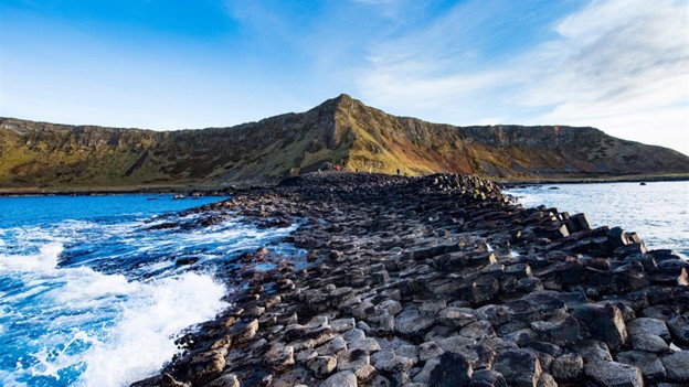
- Where: Northern Ireland
- Trail Head: Giant’s Causeway Visitor Centre
- Time Needed: 2-3 hours.
- Distance and Type: 5.6 kilometers cicuit
- Difficulty: Moderate
- When to Hike: Year-round, but best in spring or autumn
- Where to Stay: There are plenty of accommodations available in the nearby towns of Bushmills and Portrush.
The Giant’s Causeway Cliff Path is a popular hiking trail that takes you along the stunning coastline of Northern Ireland. The trail begins at the Giant’s Causeway Visitor Centre and takes you on a loop around the Causeway cliffs. Along the way, you’ll pass by impressive rock formations, sea caves, and beautiful views of the North Atlantic Ocean. The path can be steep in places, but the views are well worth the effort. The best time to hike the trail is in the spring or autumn when the weather is cooler and the crowds are thinner.
9. Slieve League Cliffs
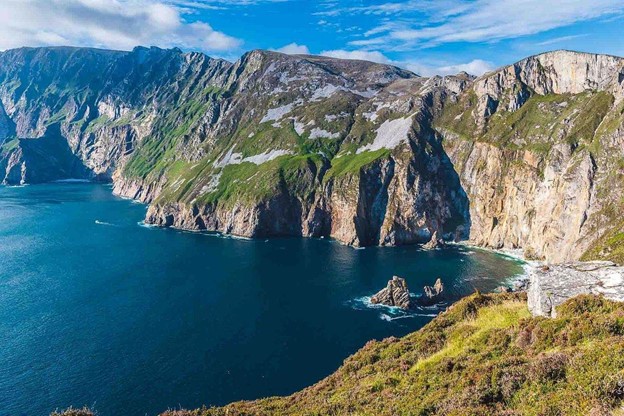
- Where: Slieve League Cliffs, County Donegal, Ireland
- Starting Point: Bunglass Car Park
- End Point: Slieve League summit
- Time Needed: 2-3 hours.
- Distance and Type: 5.1 kilometers point to point
- Difficulty: Moderate-Difficult
- When to Hike: Best time to hike is from May to September when the weather is mild, and the days are longer.
- Where to Stay: There are several accommodations available in the nearby towns of Killybegs and Donegal.
Slieve League Cliffs, also known as Sliabh Liag in Irish, is one of the highest sea cliffs in Europe, rising over 600 meters above the Atlantic Ocean. The hike to the summit of Slieve League offers breathtaking views of the rugged coastline and the surrounding mountains. The trail starts at Bunglass Car Park and follows a well-defined path up to the summit. The first section of the trail is steep and challenging, but once you reach the top, you’ll be rewarded with stunning panoramic views. The trail is well-marked and offers several viewpoints along the way. The descent can be challenging due to the steep incline, so it’s important to take your time and wear sturdy hiking shoes. Overall, the Slieve League Cliffs hike is a must-do for any avid hiker visiting Ireland.
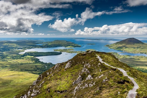
10. Diamond Hill Loop
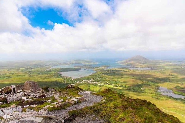
- Where: County Galway, Ireland
- Trail Head: Visitor Centre, Connemara National Park
- Time Needed: 2-3 hours.
- Distance and Type: 7 kilometers circuit
- Difficulty: Moderate
- When to Hike: The best time to hike Diamond Hill Loop is from April to October when the weather is mild, and the trails are dry. It can be busy during peak season, so it’s best to go early in the morning or later in the afternoon to avoid the crowds.
- Where to Stay: There are several accommodation options in nearby towns such as Clifden, Letterfrack, and Kylemore. Camping is not permitted within the national park.
The Diamond Hill Loop is a popular trail in Connemara National Park that offers stunning views of the surrounding countryside and the Atlantic Ocean. The trail starts at the visitor centre and takes you through a variety of landscapes including grassy fields, rocky terrain, and heather-covered mountainsides. The highlight of the hike is reaching the summit of Diamond Hill, which offers panoramic views of the Connemara coastline and the Twelve Bens Mountain range. The trail is well-maintained and easy to follow, with wooden boardwalks and stone steps in some areas.