
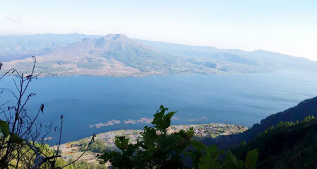
1. Mount Batur
- Where: Mount Batur is located on the island of Bali in Indonesia.
- Starting Point: Village of Toya Bungkah
- End Point: The hike ends at the summit of Mount Batur, where hikers can enjoy stunning views of the surrounding landscape.
- Time Needed: 3-4 hours.
- Distance and Type: 5 kilometers circuit
- Difficulty: Moderate-Difficult
- When to Hike: The best time to hike Mount Batur is early in the morning to catch the sunrise, or in the late afternoon to catch the sunset. The hike can be completed year-round, but weather conditions are generally better during the dry season (April-October).
- Where to Stay: Hikers may choose to stay in the nearby village of Toya Bungkah, which offers a range of accommodation options to suit different budgets. Some popular accommodation options in Toya Bungkah include Kintamani Backpackers, Lakeview Hotel and Restaurant, and Toya Devasya Hot Springs and Resort.
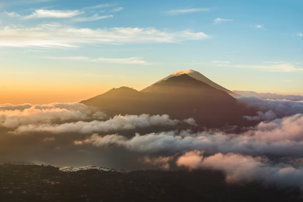
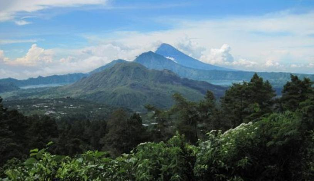
Mount Batur is an active volcano that sits at an elevation of 1,717 meters above sea level. It is one of Bali’s most popular hikes and is a must-do for adventurous travelers seeking stunning natural scenery. Hikers are advised to wear appropriate footwear, bring plenty of water and snacks, and be prepared for changing weather conditions.
2. Mount Agung

- Where: Mount Agung is located on the island of Bali in Indonesia.
- Starting Point: The hike typically starts from the Pasar Agung Temple, located at the base of the mountain.
- End Point: The hike ends at the summit of Mount Agung.
- Time Needed: 7-9 hours.
- Distance and Type: 10 kilometers circuit
- Difficulty: Difficult
- When to Hike: The best time to hike Mount Agung is during the dry season (April-October), as weather conditions are generally better and there is less chance of rain or clouds obstructing the view from the summit. It is also recommended to start the hike in the early morning to avoid extreme heat and to allow enough time to complete the trek before nightfall.
- Where to Stay: Hikers may choose to stay in the nearby town of Candidasa or Amed, which offer a range of accommodation options to suit different budgets. Some popular accommodation options in Candidasa include The Watergarden Hotel, Lotus Bungalows Candidasa, and Alila Manggis Bali. In Amed, popular options include Puri Wirata Dive Resort and Spa, Santai Hotel Amed, and Hidden Paradise Cottages.
Mount Agung is an active volcano that is considered sacred by the Balinese people. The hike to the summit offers breathtaking views of the surrounding landscape, including Bali’s other mountains, the ocean, and neighboring islands. The trek requires physical endurance, as well as mental fortitude, due to the long duration and technical sections. Hikers are advised to hire a guide, wear appropriate gear, bring plenty of water and snacks, and be prepared for changing weather conditions.
3. Campuhan Ridge Walk
- Where: The town of Ubud on the island of Bali in Indonesia.
- Starting Point: The hike typically starts from the Campuhan Bridge, located in the center of Ubud.
- End Point: The hike ends at Karsa Kafe, which is a popular restaurant that offers stunning views of the surrounding rice paddies.
- Time Needed: 1-2 hours.
- Distance and Type: 2 kilometers circuit
- Difficulty: Easy
- When to Hike: The best time to hike Campuhan Ridge Walk is in the early morning or late afternoon to avoid the midday heat and to catch the sunrise or sunset. The hike can be completed year-round, but weather conditions are generally better during the dry season (April-October).
- Where to Stay: Hikers may choose to stay in Ubud, which offers a range of accommodation options to suit different budgets. Some popular accommodation options in Ubud include The Ubud Village Resort and Spa, The Royal Pita Maha, and The Chedi Club Tanah Gajah.
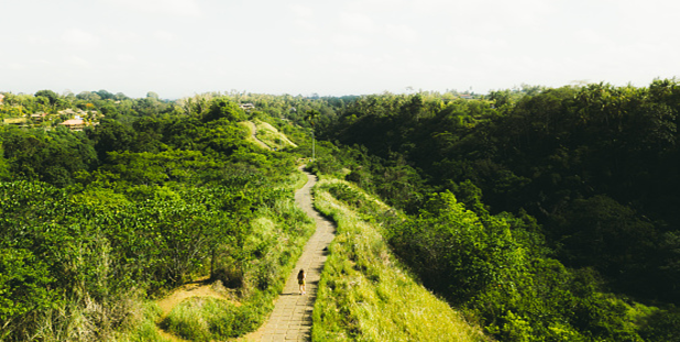
Campuhan Ridge Walk is a scenic hike that offers stunning views of the surrounding rice paddies, rivervalleys, and lush jungle. The path is surrounded by greenery and is a popular spot for nature lovers and photographers. It is a relatively easy hike, making it suitable for families with children or elderly hikers. Hikers are advised to wear comfortable shoes, bring plenty of water and sunscreen, and be respectful of the local culture and environment.
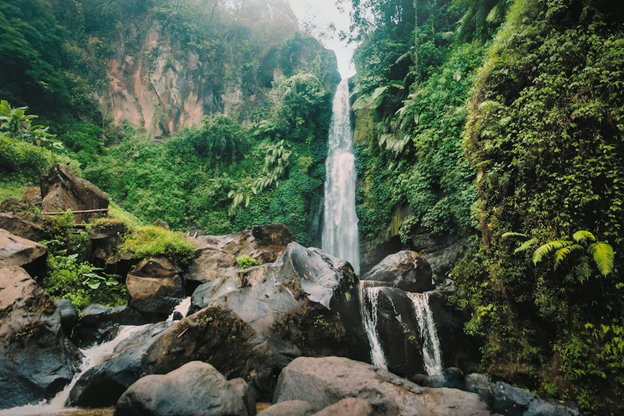
4. Sekumpul Waterfall
- Where: Sekumpul Waterfall is in the village of Sekumpul in the regency of Buleleng, about 80 km north of Denpasar on the island of Bali in Indonesia.
- Starting Point: The hike typically starts from the parking lot near the village of Sekumpul.
- End Point: The hike ends at the base of the waterfall, where visitors can take a swim in the cool water.
- Time Needed: 4-5 hours.
- Distance and Type: 7 kilometers circuit
- Difficulty: Moderate-Difficult
- When to Hike: The best time to hike Sekumpul Waterfall is during the dry season (April-October) to avoid muddy and slippery conditions. The hike can be completed year-round, but weather conditions are generally better during the dry season.
- Where to Stay: Visitors may choose to stay in the nearby town of Singaraja, which offers a range of accommodation options to suit different budgets. Some popular accommodation options in Singaraja include The Lovina Bali Resort, Puri Bagus Lovina, and Ganesha Bali Coral Reef Villas.
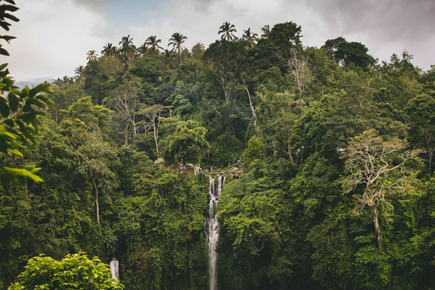
Sekumpul Waterfall is a stunning natural attraction that features multiple cascading falls surrounded by lush tropical forest. The hike to the waterfall offers breathtaking views of the surrounding landscape, and visitors can take a refreshing swim in the natural pool at the base of the falls. However, the hike involves some challenging sections and is recommended for experienced hikers or those with good physical fitness levels. Visitors are advised to wear comfortable shoes, bring plenty of water and sunscreen, and be respectful of the local culture and environment.
5. Tegalalang Rice Terrace
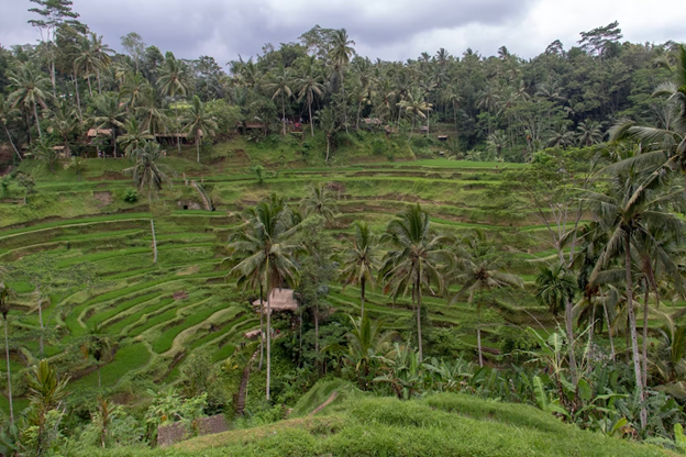
- Where: Tegalalang Rice Terrace is in the village of Tegalalang, approximately 10 km north of Ubud on the island of Bali in Indonesia.
- Starting Point: The hike typically starts from the entrance of the rice terrace complex.
- End Point: The hike ends at the exit of the complex, where visitors can enjoy local food and drinks at various cafes and restaurants.
- Time Needed: 1-2 hours.
- Distance and Type: 2 kilometers circuit
- Difficulty: Easy
- When to Hike: The best time to hike Tegalalang Rice Terrace is during the dry season (April-October) to avoid muddy and slippery conditions. However, the rice terraces are lush and green year-round, so visitors can enjoy the scenery at any time.
- Where to Stay: Visitors may choose to stay in the nearby town of Ubud, which offers a range of accommodation options to suit different budgets and preferences. Some popular accommodation options in Ubud include Four Seasons Resort Bali at Sayan, Ubud Hanging Gardens, and Komaneka at Bisma.
Tegalalang Rice Terrace is a picturesque agricultural attraction that features sprawling rice terraces carved into the hillside. The hike offers breathtaking views of the surrounding landscape and provides visitors with a glimpse into the traditional farming practices of the Balinese people. Visitors can take a leisurely stroll through the rice terraces, stop to take photos, and enjoy the peaceful surroundings. Local cafes and restaurants offer traditional Balinese dishes and refreshments, making it a perfect spot for a relaxing afternoon.
6. Mount Abang
- Where: Mount Abang is in the Bangli Regency in eastern Bali, approximately 2.5 hours from the tourist hub of Ubud.
- Starting Point: The hike typically starts from the parking area at Pura Dalem Pingit temple, which is the nearest access point to the summit.
- End Point: The hike ends at the summit of Mount Abang, which offers panoramic views of Bali’s mountains and coastline.
- Time Needed: 4-5 hours.
- Distance and Type: 8 kilometers circuit
- Difficulty: Moderate
- When to Hike: The best time to hike Mount Abang is during the dry season (April-October) to avoid slippery conditions and heavy rainfall. It is recommended to start the hike early in the morning to avoid the midday heat and to reach the summit before sunrise.
- Where to Stay: Visitors may choose to stay in the nearby town of Bangli, which offers a range of accommodation options to suit different budgets and preferences.Some popular accommodation options in Bangli include Surya Shanti Villa and Villa Agung Khalia.
Mount Abang is the third highest mountain in Bali, standing at an elevation of 2,152 meters above sea level. The hike offers stunning views of Bali’s volcanic landscape, including Mount Batur and Mount Agung. The trek involves steep inclines and rocky terrain, but the rewarding views from the summit make it worth the effort. Visitors can witness the sunrise over the mountains and coastline, and explore the surrounding area, including nearby waterfalls and hot springs. It is recommended to hire a local guide for the hike, as the trail can be challenging to navigate.
7. Mount Batukaru
- Where: Mount Batukaru is in central Bali, approximately 2 hours from the tourist hub of Ubud.
- Starting Point: The hike typically starts from the Batukaru Temple, which is the nearest access point to the summit.
- End Point: The hike ends at the summit of Mount Batukaru, which offers panoramic views of Bali’s mountains and coastline.
- Time Needed: 6-7 hours.
- Distance and Type: 10 kilometers circuit
- Difficulty: Difficult
- When to Hike: The best time to hike Mount Batukaru is during the dry season (April-October) to avoid slippery conditions and heavy rainfall. It is recommended to start the hike early in the morning to avoid the midday heat and to reach the summit before sunrise.
- Where to Stay: Visitors may choose to stay in the nearby town of Tabanan or in the mountainous region of Bedugul, which offers a range of accommodation options to suit different budgets and preferences. Some popular accommodation options in Tabanan include Villa Lumbung Bali and Alila Villas Soori, while Bedugul offers a range of budget-friendly options, such as guesthouses and homestays.
Mount Batukaru is the second highest mountain in Bali, standing at an elevation of 2,276 meters above sea level. The hike offers stunning views of Bali’s mountainous landscape, including rice terraces, waterfalls, and lush jungle. The trek involves steep inclines and rugged terrain, but the rewarding views from the summit make it worth the effort. Visitors can witness the sunrise over the mountains and coastline, and explore the surrounding area, including nearby hot springs and temples. It is recommended to hire a local guide for the hike, as the trail can be challenging to navigate.
8. Gitgit Waterfall
- Where: Gitgit Waterfall is in North Bali, approximately 11 kilometers south of Singaraja.
- Starting Point: The starting point of the hike to Gitgit Waterfall is a parking lot near the entrance of the waterfall park.
- End Point: The hike ends at Gitgit Waterfall, which is a 40-meter-high waterfall and one of the most popular waterfalls in Bali.
- Time Needed: 1 hour.
- Distance and Type: 1.5 kilometers circuit
- Difficulty: Easy
- When to Hike: Gitgit Waterfall is open all year round, but the best time to visit is during the dry season (April-October) to avoid slippery conditions and heavy rainfall. It is recommended to visit early in the morning to avoid the crowds and to enjoy the cool morning air.
- Where to Stay: Visitors may choose to stay in nearby towns such as Singaraja or Lovina, which offer a range of accommodation options to suit different budgets and preferences. Some popular accommodation options in Singaraja include Aditya Beach Resort and Puri Bagus Lovina Resort, while Lovina offers a range of budget-friendly options, such as guesthouses and homestays.
Gitgit Waterfall is a beautiful waterfall located in a lush jungle setting. The hike to the waterfall is relatively easy and suitable for all ages and fitness levels. Visitors can enjoy the refreshing spray of the waterfall and swim in the natural pool at the base of the falls. The surrounding area is also home to other waterfalls and scenic rice paddies, making it a popular destination for nature lovers. It is recommended to wear sturdy shoes and bring a swimsuit, towel, and camera for this hike.
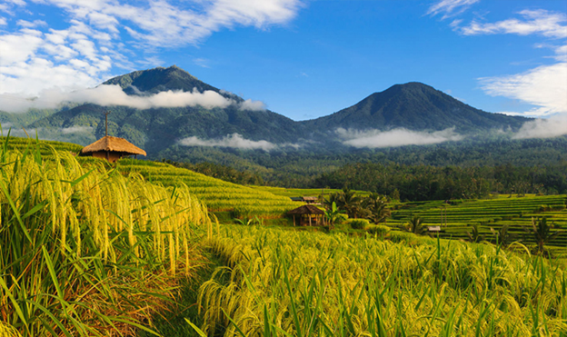
9. Mount Catur

- Where: Mount Catur is in Bali, Indonesia.
- Starting Point: Pura Luhur Batukaru temple.
- End Point: Same as the starting point.
- Time Needed: 5-6 hours.
- Distance and Type: 10 kilometers circuit
- Difficulty: Moderate-Difficult
- When to Hike: The best time to hike Mount Catur is during the dry season, which is between April and September.
- Where to Stay: There are several accommodations in the nearby area for those who wish to stay overnight, including guesthouses and villas. Some recommended accommodations near Mount Catur include The Griya Villas and Spa, Munduk Moding Plantation Nature Resort & Spa, and Padma Resort Ubud.
Mount Catur offers hikers stunning views of the surrounding landscape, including the island’s famous rice terraces and Lake Beratan. The hike is moderately challenging, with steep inclines and rocky terrain, but the stunning views at the top are well worth the effort. The summit also offers views of several other Bali mountains, including Mount Agung and Mount Batukaru.
10. Mount Merbuk
- Where: Mount Merbuk is in west Bali, near the town of Gilimanuk.
- Starting Point: The starting point for the hike is at the Pura Dalem Merbuk temple.
- End Point: The end point is the summit of Mount Merbuk.
- Time Needed: 4-5 hours.
- Distance and Type: 10 kilometers circuit
- Difficulty: Moderate
- When to Hike: The best time to hike Mount Merbuk is during the dry season, from May to September.
- Where to Stay: There are no accommodation options on Mount Merbuk, but there are plenty of places to stay in nearby Gilimanuk or Pemuteran.Popular accommodation options in the area include Taman Sari Bali Resort & Spa and Amertha Bali Villas Beachfront Resort & Spa.
Mount Merbuk is an active volcano that offers stunning views of the surrounding landscape, including Bali’s western coastline and the Java Sea. The hike to the summit can be challenging due to the steep inclines, but the panoramic views from the top make it well worth the effort. The trail takes hikers through lush forests and across rocky terrain, and the ascent becomes steeper as you near the summit. At the top, hikers are rewarded with breathtaking views of Bali’s coastline and surrounding islands.