

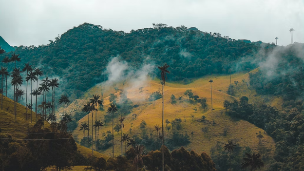
1. Cocora Valley
- Where: Cocora Valley is in the central Andes of Colombia, near the town of Salento in the Quindio department.
- Starting Point: The hike typically starts at the entrance of Cocora Valley, which is accessible by car, taxi, or jeep from Salento.
- End Point: The end point of the hike is typically the same as the starting point.
- Time Needed: 6-7 hours.
- Distance and Type: 12 kilometers circuit
- Difficulty: Moderate-Difficult
- When to Hike: Dry season, which spans from December to March and from July to September. During this time, the weather is typically clear, and the trail conditions are better.
- Where to Stay: There are several guesthouses and hostels in Salento that cater to hikers and backpackers, including La Serrana Hostel, Plantation House, and La Posada de la Plaza. There are also camping options available in the Cocora Valley.
The Cocora Valley is one of the most picturesque and popular hiking destinations in Colombia. The valley is home to the towering wax palm trees, which can grow up to 60 meters tall and are the national tree of Colombia. The hike takes you through cloud forests, past rushing rivers, and streams, and over hills with stunning views of the valley and the surrounding mountains. The highlight of the hike is the Salento viewpoint, which offers an incredible panoramic view of the valley and the towering wax palms. Along the way, you may also encounter some of the local wildlife, such as toucans, hummingbirds, and the Andean condor.
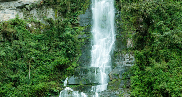
2. La Chorrera Waterfall
- Where: La Chorrera Waterfall is in the Andes Mountains, near the town of Choachi in Cundinamarca, Colombia.
- Starting point: The starting point of the hike to La Chorrera Waterfall is at the entrance of the park, which is located about a 1.5-hour drive from Bogota.
- End point: The end point is at the waterfall itself, where you can enjoy the stunning views of the 590-meter waterfall.
- Time needed: 3-4 hours.
- Distance and Type: 7 kilometers circuit
- Difficulty: Moderate
- When to Hike: La Chorrera Waterfall is best hiked during the dry season in Colombia, which falls between December to March and June to August. It is not recommended to hike during the rainy season, as the trail can become slippery and dangerous.
- Where to Stay: There are a variety of accommodation options in Bogota, including hotels, hostels, and apartments. Some popular options include Hotel Casa Deco, Selina La Candelaria, and Hostal R10.
La Chorrera Waterfall is the highest waterfall in Colombia and one of the highest in South America. The hike to the waterfall takes you through a lush forest with beautiful flora and fauna, including orchids, butterflies, and hummingbirds. Along the way, you will encounter several smaller waterfalls and streams before arriving at the breathtaking La Chorrera Waterfall. The waterfall is surrounded by cliffs and lush vegetation, making for a stunning sight. You can also take a dip in the natural pool at the base of the waterfall, which is a refreshing break from the hike.
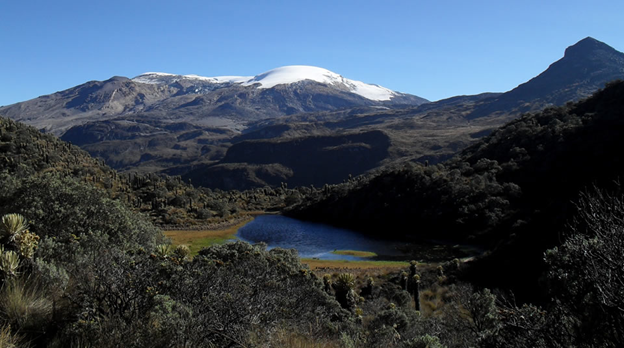
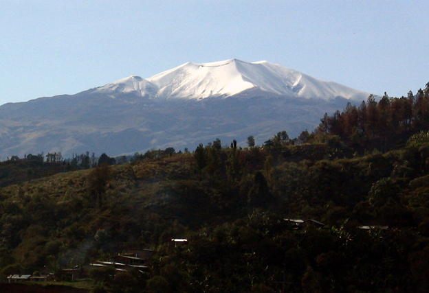
3. Los Nevados National Park
- Where: Los Nevados National Park is in the central range of the Colombian Andes, about 130 km from the city of Pereira.
- Starting point: The Santa Isabel trail starts at the entrance to the park at the end of the road leading to the Termales del Ruiz hotel.
- End point: The end point of the hike is typically the same as the starting point.
- Time needed: 6-8 hours.
- Distance and Type: 12 kilometers circuit
- Difficulty: Moderate-Difficult
- When to Hike: The best time to hike in Los Nevados National Park is during the dry season, from December to March and from July to September. However, the weather can be unpredictable and change quickly, so it’s best to check conditions before heading out.
- Where to Stay: There are several accommodation options near the park, including the Termales del Ruiz hotel and a few rustic lodges in the surrounding villages.
The Santa Isabel trail is one of the most popular hikes in Los Nevados National Park, offering stunning views of the snow-capped peaks and the surrounding valleys. The trail begins at the entrance to the park and follows a well-marked path through paramo grasslands and rocky terrain. Along the way, you’ll pass several streams and waterfalls, as well as the occasional Andean condor soaring overhead. The highlight of the hike is the summit of Cerro Santa Isabel, which offers panoramic views of the park and the surrounding mountains. Be prepared for cold temperatures and strong winds at the summit, and make sure to bring plenty of water and warm clothing.
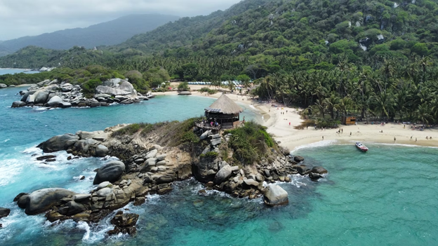
4. Tayrona National Park
- Where: Tayrona National Park is located on the Caribbean coast of Colombia, about 34 km from the city of Santa Marta.
- Starting Point: The starting point for this day hike is the park entrance at Cañaveral, which is about a 1-hour drive from Santa Marta.
- End Point: The end point is Cabo San Juan, a beautiful beach at the edge of the park where you can relax and take a dip in the ocean.
- Time Needed: 6-7 hours.
- Distance and Type: 12.4 kilometers circuit
- Difficulty: Moderate
- When to Hike: The best time to hike in Tayrona National Park is during the dry season, which runs from December to March and July to August. However, the park is open year-round and can be visited during other times as well.
- Where to Stay: There are several options for accommodation within the park, including rustic cabins and hammocks for rent at Cabo San Juan. If you prefer a more comfortable stay, there are also several lodges and hotels in the nearby town of Santa Marta.
Tayrona National Park is a stunning coastal park that features a variety of landscapes, including beaches, forests, and mountains. The day hike from Cañaveral to Cabo San Juan takes you through some of the park’s most beautiful scenery, including dense forests and rocky beaches. Along the way, you’ll see a variety of wildlife, including monkeys, iguanas, and exotic birds. Cabo San Juan is a highlight of the hike, with its crystal-clear waters and stunning views of the Caribbean Sea. This day hike is a great way to experience the natural beauty of Tayrona National Park in a single day.
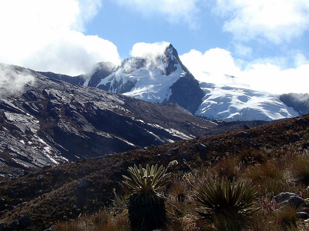
5. Purace National Park
- Where: Purace National Park is in the southern part of Colombia in the Andean region.
- Starting Point: The starting point for the trail is the Purace National Park entrance.
- End Point: The end point is the summit of Purace Volcano.
- Time Needed: 6-8 hours.
- Distance and Type: 14 kilometers circuit
- Difficulty: Difficult
- When to Hike: The best time to hike Purace National Park is during the dry season, which runs from December to March and from July to September. The weather is cooler and there is less chance of rain during these months.
- Where to Stay: There are several accommodation options near Purace National Park, including hostels, camping sites, and cabins. The closest city is Popayan, where you can find a range of accommodation options to suit your budget.
The trail to the summit of Purace Volcano takes you through lush vegetation and provides stunning views of the surrounding landscape. The hike is challenging, but the reward is worth it as you will have an amazing panoramic view of the Purace Volcano, the surrounding mountains, and valleys, and on clear days you can see the Pacific coast in the distance. The park is home to a variety of wildlife including Andean condors, llamas, and spectacled bears. It is also home to several hot springs which can be a perfect way to relax after the hike.
6. El Cocuy National Park
- Where: El Cocuy National Park is in the Andes mountains of northeastern Colombia.
- Starting point: The starting point for this day hike is the town of Guican.
- End point: The end point for this day hike is the Laguna Grande de la Sierra, a high-altitude glacial lake.
- Time needed: 5-7 hours.
- Distance and Type: 8.5 kilometers circuit
- Difficulty: Moderate-Difficult
- When to Hike: The best time to hike in El Cocuy National Park is from December to February or from June to August when the weather is dry and clear.
- Where to Stay: Guican has several accommodation options, including hostels and guesthouses.
This day hike in El Cocuy National Park is a challenging but rewarding experience, as hikers will be able to see stunning views of the surrounding Andes mountains and the Laguna Grande de la Sierra, a beautiful glacial lake. The trail is steep and rocky in some sections, and hikers should be prepared for the altitude and weather conditions. Hikers should also bring enough food and water for the day, as there are no facilities along the trail.
7. Sumapaz Páramo (Laguna de Chisacá trail)
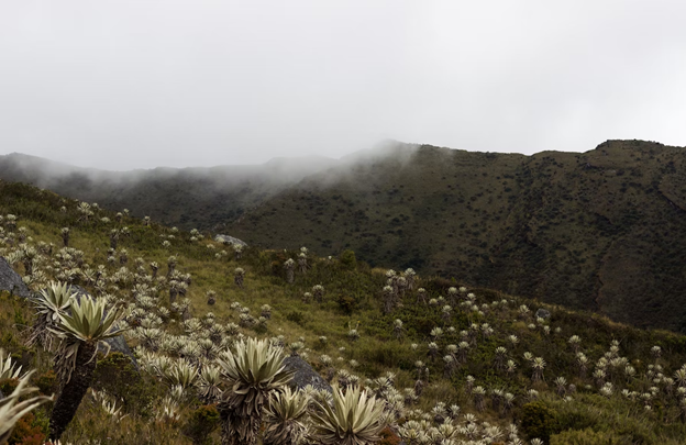
- Where: Sumapaz Páramo, Cundinamarca, Colombia
- Starting Point: Chisacá
- End Point: Laguna de Chisacá
- Time Needed: 5-6 hours.
- Distance and Type: 10.6 kilometers circuit
- Difficulty: Moderate-Difficult
- When to Hike: The dry season (December – February, and June – August) is the best time to hike in Sumapaz Páramo. The trail may be closed during the rainy season due to weather conditions.
- Where to Stay: There are no accommodations within Sumapaz Páramo, but you can find lodging options in nearby towns such as Fusagasugá and Bogotá.
The Laguna de Chisacá trail takes hikers through beautiful high-altitude páramo landscapes and ends at a stunning glacial lake. The trail begins at the village of Chisacá and ascends through rugged terrain to reach the lake, which sits at an elevation of 3,850 meters. Along the way, hikers will enjoy stunning views of the surrounding mountains and valleys. Due to the high altitude and rugged terrain, this trail is considered moderate to difficult and may be challenging for inexperienced hikers. It is important to bring plenty of water, warm clothing, and snacks for the journey.
8. Chicaque Natural Park (La Cascada trail)
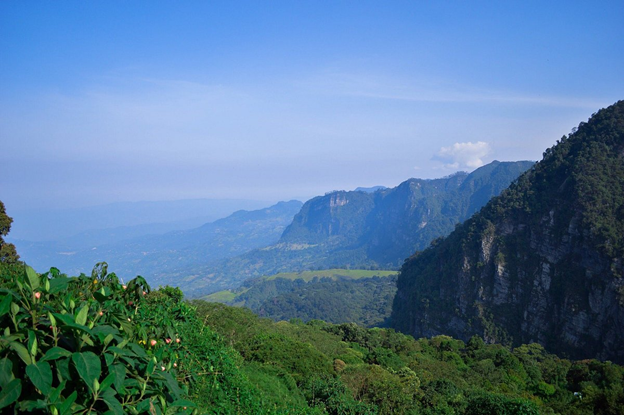
- Where: Chicaque Natural Park is in the department of Cundinamarca, approximately 45 minutes from Bogotá, Colombia.
- Starting point: The trailhead for the La Cascada trail is located near the park entrance.
- End point: The trail ends at a viewpoint overlooking a waterfall.
- Time needed: 2-3 hours.
- Distance and Type: 2.5 kilometers.
- Difficulty: Moderate-Difficult
- When to Hike: The park is open year-round, but it’s best to hike during the dry season (December to February and July to August) to avoid muddy trails.
- Where to Stay: The park offers camping and cabin accommodations, or you can stay in nearby hotels in Soacha or Bogotá.
Chicaque Natural Park is a cloud forest reserve that boasts over 300 species of birds, including the colorful Andean cock-of-the-rock. The La Cascada trail is one of the park’s most popular hikes and takes you through lush forest to a viewpoint overlooking a beautiful waterfall. Along the way, you’ll encounter a variety of flora and fauna, including orchids, ferns, and hummingbirds. The park is also home to a variety of wildlife, including howler monkeys, coatis, and deer. The park offers a peaceful escape from the hustle and bustle of Bogotá and is a great option for a day hike or overnight camping trip.
9. El Peñón de Guatapé
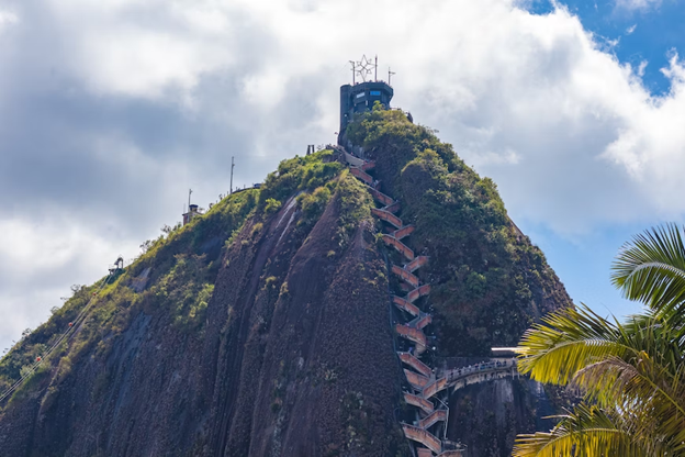
- Where: El Peñón de Guatapé is in the town of Guatapé in the Antioquia department of Colombia.
- Starting point: The starting point is the base of the rock, where you can buy your admission ticket and begin the climb.
- End point: The end point is the summit of the rock, where you will be rewarded with breathtaking views of the surrounding landscape.
- Time needed: 2 hours.
- Distance and Type: The distance of the climb is around 740 steps.
- Difficulty: Moderate
- When to Hike: The best time to climb El Peñón de Guatapé is early in the morning or late in the afternoon, as the midday sun can be intense.
- Where to Stay: Guatapé has a variety of accommodation options, including hotels, hostels, and vacation rentals. Some popular options include Hotel Los Recuerdos, Hotel Llanogrande Inn, and Hostal del Parque.
El Peñón de Guatapé is a massive rock formation that rises 200 meters above the surrounding landscape. The hike to the summit of the rock is a popular activity for visitors to the town of Guatapé, as it offers stunning views of the surrounding countryside. At the summit, there is a viewing platform where you can take in the panoramic vistas and snap some memorable photos. Along the way, you’ll also see colorful graffiti and artwork on the stairs, adding to the unique charm of this popular attraction.
10. Monserrate
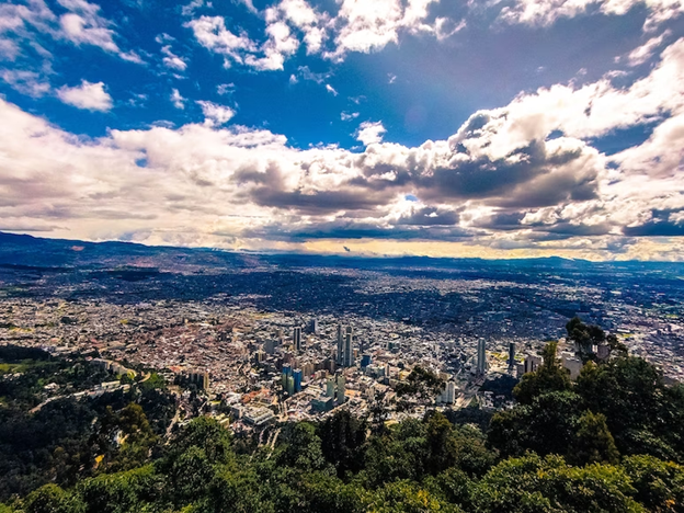
- Where: Bogotá, Colombia
- Starting point: The mountain from the town of La Candelaria, which is about 2.5km away from the base of the mountain. Alternatively, you can take a cable car or funicular from the base of the mountain to the top.
- End point: The summit of Monserrate Mountain
- Time needed: Hiking: around 1.5-2 hours each way; Cable car or funicular: approximately 10-15 minutes each way.
- Distance and Type: Hiking: 2.5 kilometers each way; Cable car or funicular: about 1.5 kilometers each way.
- Difficulty: Moderate-difficult
- When to Hike: Monserrate can be hiked year-round, but it is best to avoid the rainy season (April-May and October-November) as the trails can become slippery and dangerous.
- Where to Stay: There are many accommodation options in Bogotá, ranging from budget hostels to luxury hotels. Some popular areas to stay include La Candelaria (the historic center of Bogotá) and the trendy neighborhoods of Chapinero and Zona Rosa.
Monserrate is a popular tourist attraction in Bogotá, offering stunning views of the city from its summit, which stands at an elevation of 3,152 meters above sea level. The mountain has been considered a sacred site since pre-Columbian times and is now home to a church and pilgrimage site. The cable car or funicular ride to the top is a popular option for those who want to avoid the steep hike, but the hike itself is a rewarding experience for those who are up for the challenge. Along the trail, hikers can enjoy the natural beauty of the mountain and observe local flora and fauna. At the summit, visitors can take in panoramic views of the city and surrounding landscape, as well as visit the church and enjoy local food and drink at the restaurants and shops.