1. Tarzan Falls
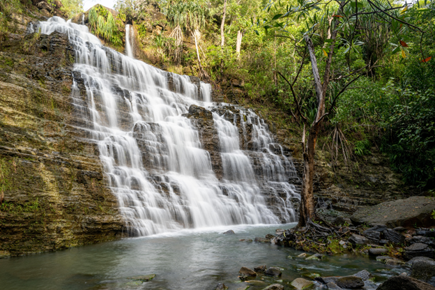
- Where: Yona, Guam
- Starting point: Ylig Bridge
- End point: Tarzan Falls
- Time needed: 1-2 hours.
- Distance and Type: 3.2 kilometers circuit
- Difficulty: Moderate-Difficult
- When to Hike: Year-round, but best during the dry season (December to May).
- Where to Stay: There are several hotels and resorts located in Tumon Bay, about a 30-minute drive from the Yona area.
The Tarzan Falls hike is one of the most popular trails in Guam, taking hikers through dense jungle foliage and steep inclines to reach the breathtaking waterfall at the end. The hike can be quite challenging, with narrow paths and slippery rocks to navigate, but the reward of seeing the stunning falls up close makes it all worth it. It’s recommended to wear sturdy hiking shoes, bring plenty of water, and take caution on the slippery sections of the trail. Overall, the Tarzan Falls hike is a must-do for any outdoor enthusiast visiting Guam.
2. Fonte River Falls

- Where: Southeast of Guam, in the village of Talofofo
- Starting point: Talofofo Elementary School parking lot
- End point: Fonte River Falls
- Time needed: 1-2 hours.
- Distance and Type: 1.6 kilometers circuit
- Difficulty: Easy
- When to Hike: Year-round, but best during dry season (January to May).
- Where to Stay: There are no accommodations near Fonte River Falls, but there are various options in nearby Talofofo village or in Guam’s main tourist areas of Tumon and Tamuning.
Fonte River Falls is a popular hiking destination in Guam, located in the village of Talofofo. The trailhead starts from the Talofofo Elementary School parking lot and winds through a scenic jungle landscape, crossing the Fonte River several times. The trail is well-maintained and suitable for hikers of all skill levels, with a relatively short distance of only 1.6 km round trip. Along the way, hikers can enjoy views of the river, lush vegetation, and wildlife. The falls themselves are a beautiful sight, cascading into a refreshing swimming hole that’s perfect for a dip after the hike. The best time to hike to Fonte River Falls is during the dry season, from January to May, when the water levels are lower, and the trail is less muddy.
3. Mount Lamlam
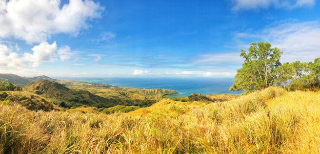
- Where: Mount Lamlam is in the village of Agat in Guam.
- Starting Point: The hike to Mount Lamlam starts from the parking area near the Lamlam Beach Lookout.
- End Point: The end point of the hike is the summit of Mount Lamlam.
- Time Needed: 2-3 hours.
- Distance and Type: 5 kilometers circuit
- Difficulty: Moderate-Difficult.
- When to Hike: It is best to hike in the early morning hours to avoid the heat of the day.
- Where to Stay: There are several accommodations available in the nearby villages of Agat and Umatac.
Mount Lamlam is the highest point on the island of Guam, offering breathtaking panoramic views of the island and the ocean beyond. The trail is challenging, with steep inclines and rocky terrain, but the stunning views from the summit make the effort worthwhile. Hikers should bring plenty of water, wear sturdy hiking shoes, and be prepared for a challenging hike.
4. Lost Pond Trail
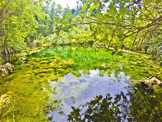
- Where: Lost Pond Trail is in Tumon Bay, Guam.
- Starting point: The parking lot of the Tumon Bay lookout.
- End point: The Lost Pond, which is a natural freshwater pool.
- Time needed: 30 minutes to an hour.
- Distance and Type: 1.5 kilometers circuit
- Difficulty: Easy-Moderate
- When to Hike: The best time to hike the Lost Pond Trail is during the dry season, which runs from December to May.
- Where to Stay: There are plenty of accommodations available in Tumon Bay, which is close to the trailhead.
The Lost Pond Trail is a beautiful hike that offers stunning views of the surrounding area. The trail winds through the forest, passing by streams and waterfalls before reaching the natural freshwater pool. The pool is a popular spot for swimming and relaxing, and there are plenty of shady spots around the pond to rest and enjoy the scenery. The trail is well-marked and easy to follow, making it a great choice for families and beginner hikers.
5. Talofofo Caves

- Where: Talofofo, Guam
- Starting point: Talofofo Bay Overlook
- End point: Talofofo Caves
- Time needed: 2-3 hours.
- Distance and Type: 4.8 kilometers circuit
- Difficulty: Moderate
- When to Hike: Best to hike early in the morning or late afternoon to avoid the heat of the day.
- Where to Stay: There are several accommodations in the nearby towns of Talofofo and Yona.
The Talofofo Caves hike is a moderately challenging out-and-back trail that leads hikers to a series of naturally formed caves. The trail begins at the Talofofo Bay Overlook and takes hikers through dense jungle terrain and across a small river before reaching the caves. The caves themselves are a unique sight to see, with natural rock formations and clear, cool water pools. It’s important to note that the trail can be slippery and muddy, so wearing appropriate footwear is recommended. Overall, the Talofofo Caves hike is a rewarding adventure for hikers looking for a unique and memorable experience on the island of Guam.
6. Pagat Caves
- Where: Pagat Caves, Guam
- Starting Point: Pagat village
- End Point: Pagat Caves
- Time Needed: 2-3 hours.
- Distance and Type: 5 kilometers circuit
- Difficulty: Moderate
- When to Hike: The best time to hike is during the dry season (December through June) to avoid muddy and slippery conditions on the trail.
- Where to Stay: There are a variety of lodging options available in Guam, including hotels and vacation rentals.
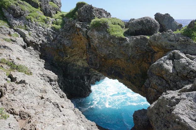
Pagat Caves is a popular hiking destination in Guam that offers beautiful views of the Pacific Ocean and unique limestone caves. The trail is well-marked and takes hikers through lush vegetation and along a rocky coastline. The caves themselves are an amazing sight to see, with stalactites and stalagmites formed over thousands of years. It’s important to bring proper hiking gear and plenty of water, as the trail can be steep and challenging at times. Overall, Pagat Caves is a must-visit destination for any nature lover visiting Guam.
7. Fintasa Waterfall

- Where: Fintasa, Guam
- Starting point: The trailhead is located at the end of the Fintasa Road.
- End point: Fintasa Waterfall
- Time needed: 2-3 hours.
- Distance and Type: 5.6 kilometers circuit
- Difficulty: Moderate
- When to Hike: The best time to hike is during the dry season, which runs from January to June.
- Where to Stay: There are several accommodation options available in the nearby towns of Talofofo and Inarajan.
Fintasa Waterfall is a stunning natural wonder located in the heart of Guam’s tropical jungle. The trail leading to the waterfall is surrounded by lush vegetation and offers visitors stunning views of the surrounding landscape. The hike to the waterfall is moderately challenging, with several steep inclines and rocky terrain. However, the effort is well worth it, as Fintasa Waterfall is a beautiful and refreshing oasis that is sure to delight hikers of all skill levels.
8. Mount Jumullong Manglo
- Where: The island of Guam in the western Pacific Ocean.
- Starting point: The base of the mountain.
- End point: The summit of the mountain.
- Time needed: 3-4 hours.
- Distance and Type: 4 kilometers circuit
- Difficulty: Moderate-Difficult
- When to Hike: The best time to hike is in the early morning when it is cooler and less humid.
- Where to Stay: There are no accommodation options at the trailhead, but there are plenty of hotels and resorts in the nearby town of Tamuning.
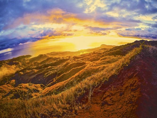
Mount Jumullong Manglo is one of the highest peaks on Guam, offering panoramic views of the island and the Pacific Ocean. The hike to the summit is a challenging but rewarding experience, featuring steep inclines, rocky terrain, and stunning vistas. Along the way, hikers can enjoy the lush tropical foliage and local wildlife, including fruit bats and colorful birds. At the summit, hikers can take in the breathtaking views and snap some memorable photos before making the descent back down the mountain. Overall, Mount Jumullong Manglo is a must-see destination for outdoor enthusiasts visiting Guam.
9. Sigua Falls

- Where: Sigua Falls, located in the village of Adelup in Guam.
- Starting point: The trailhead is located near the parking area off Route 17.
- End point: The endpoint is the stunning Sigua Falls.
- Time needed: 4-5 hours.
- Distance and Type: 7.2 kilometers circuit
- Difficulty: Moderate-Difficult
- When to Hike: It is recommended to hike in the dry season, from December to June, as the trail can be slippery and muddy during the wet season.
- Where to stay: There are no accommodation options near Sigua Falls, so it is recommended to stay in a hotel or rental property in nearby towns such as Tumon or Hagatna.
Sigua Falls is a beautiful waterfall located in the southern part of Guam. The trail to the falls is well-maintained and relatively easy to follow, with several scenic viewpoints along the way. The waterfall itself is a stunning sight, with crystal-clear water cascading over moss-covered rocks into a serene pool below. Visitors can swim in the pool and cool off in the refreshing water. Overall, Sigua Falls is a must-visit destination for nature lovers and hikers visiting Guam.
10. Fadian Cave

- Where: Fadian Cave is in the northern part of Guam, near Ritidian Point.
- Starting Point: Ritidian Beach parking lot.
- End Point: Fadian Cave.
- Time Needed: 1-2 hours.
- Distance and Type: 2.4 kilometers circuit
- Difficulty: Moderate
- When to Hike: It’s best to hike to Fadian Cave during the dry season when the weather is less rainy and muddy.
- Where to Stay: There are no accommodations near Fadian Cave, but there are several options in nearby towns such as Dededo or Hagåtña.
Fadian Cave is a large cave located on the cliffs overlooking Ritidian Beach. The cave was once used by the ancient Chamorro people for shelter and storage. Visitors can explore the cave and take in the stunning views of the coastline from the cave’s entrance. The hike to Fadian Cave is a popular activity for tourists and locals alike, and it’s a great way to experience Guam’s natural beauty and learn about its rich history.

